Brace for more floods in Rwenzori - Experts
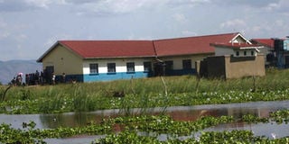
Rwangara Health Centre II in Ntoroko District that has been affected by rising water from Lake Albert since last year. Experts say more disasters will continue to be experienced in the sub-region. PHOTO/ FILE
What you need to know:
- The experts say all the buffer zones in the ranges of Mt Rwenzori have been depleted by human activities such as cultivation.
Experts have warned that environment disasters in Rwenzori Sub-region may not end soon due to continued degradation of the ecosystem.
The National Environment Management Authority (Nema) officer for south western region, Mr Jeconious Musingwire, says all the buffer zones in the ranges of Mt Rwenzori have been depleted by human activities such as overgrazing and cultivation.
He says in the past, all the ranges of Mt Rwenzori both in Uganda and DR Congo had wetlands but this is no longer the case.
“Today, that is why we are witnessing floods coming from Mount Rwenzori to downstream during the dry season because the ranges have tropical forests, which form rainfall all the time,” he says.
“And because all the buffer zones in the ranges were depleted, they can’t retain waters any more, hence causing flooding and mudslides downstream,” he adds.
Mr Musingwire said the increasing human activity is to blame for the continuous floods and mudslides.
“Whenever it rains in the hilly areas, the bare steep slopes cannot retain the runoff and water goes onto the gentle slopes where it cannot be retained. It is never retained in the lower lands too because their wetlands have been degraded,” he explains.
Mr Musingwire adds that the tree cover in the mountain ranges, which used to hold soils intact and act as catchment for floods, has also been depleted.
“All rivers from the ranges are supposed to have buffer zones with a minimum of 100 metres and they are supposed to be free from any human activities but because of degradation, these rivers have been encroached on and people have established gardens, and when it rains up in the mountains, everything is washed downstream,” he adds.
Mr Musingwire advises that the permanent solution is to restore the depleted ecosystem in the area by planting trees on the river banks and on the mountain ranges.
“If people stop all human activities on the river banks, the buffer zones will be restored,” he says.
Unpredictable phenomena
Mr Brian Guma, the team leader of the Lake Albert management zone, says due to depletion of the ecosystem, the disasters in Rwenzori Sub-region cannot be predicted.
“Today, disasters in the Rwenzori region are not predictable, the rains we used to receive in May now come in July, and they come when they are heavy and cause a lot of destruction,” he says. The minister for Disaster Preparedness, Mr Hilary Onek, while visiting Bundibugyo and Kasese districts last month, also attributed constant flooding and landslides in the area to increased human pressure on land in the mountain ranges.
The minister said because of the steepness of the ranges, it becomes easy for landslides and floods to occur when the vegetation is depleted.
“People have continued to cultivate on all ranges of Mt Rwenzori, and that is why landslides are common. We need to reduce on the number of population staying in hilly areas and also we restore the area by planting more trees. The leaders need to start discouraging people from cultivating in hilly areas,” he said.
Most rivers in the sub-region originate from Mount Rwenzori and snake through the districts of Kasese, Ntoroko, Bunyangabu, Kabarole and Bundibugyo before pouring into Lake George.
In Kasese, rivers such as Nyamwamba, Mubuku, Nyamugasani, Lhubiriha, Sebwe and Thako have over the last 10 years continued to burst their banks, displacing surrounding communities.
For instance, River Mubuku that passes through Ibanda-Kyanya Town Council last year swept away classrooms at Bikone Primary School.
Other rivers in Bundibugyo such as Tokwe, Kirumya, Maruru, Humya, Nyabulere, Nyabughesere and Lamia pour into River Semuliki in Ntoroko District. However, these rivers are also suffering under the weight of human activities such as sand mining and encroachment on their banks by farmers.
In June, the President, while in Kasese, asked the leaders to talk to the people who were displaced by floods to see if they agree to be relocated to other places outside the district.
Mr Guma said the Ministry of Water and Environment has developed the restoration plan for River Nyamwaba and Mubuku and they are only waiting for funding.
In March, leaders in Kasese embarked on a campaign of saving River Nyamwamba by planting bamboo trees on its banks.
Devastating impact
The effects of environment degradation have been flooding, leading to loss of lives and property. For example, since 2019, parts of Ntoroko District such as Kanara Sub-county and Kanara Town Council have been submerged by floods after rising water levels from Lake Albert.
This has left more 10,000 people displaced, with primary schools such as Umoja, Rwangara, and Kachwakumu still submerged.
In Kasese District, more than 5,000 people are still staying in different camps after being displaced by floods last year.
President Museveni, while addressing journalists at Fort Portal State Lodge in 2019 promised that the government would build dams to trap access water in Ntoroko. However, this is yet to be done.
