Prime
Demarcation of L. Kyoga buffer zone commences
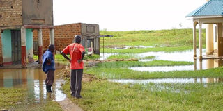
Some of the residents whose properties were submerged by floods at Lwampanga Sub-county in Nakasongola District last month. PHOTO/FILE

What you need to know:
- The exercise, which will cost Shs7m, has kicked off at lake shore areas of Kalungi Sub-county.
A uthorities in Nakasongola District have started demarcating sections of Lake Kyoga and River Sezibwa buffer zones to protect communities from being displaced by floods as a result of rising water levels.
The demarcation will include erecting concrete pillars and sensitisation of the population against conducting human activities within the buffer zones.
A buffer zone is an area of land designated for environmental protection. According to the Nema Act, any person constructing a permanent structure in a 200-metre buffer zone needs clearance.
Mr Sam Kigula, the district chairperson, on Wednesday said the demarcation will also protect water and wetland resources.
“The demarcation exercise has already kicked off at the different fish landing sites and villages. We also have a debate on areas where the flash floods displaced residents from areas that are about 1km from the low water mark.
We urge local leaders to join the district authorities to sensitise residents who occupy areas near the lake shores,” Mr Kigula said.
“It is unfortunate that the flash floods have now displaced more than 5,000 households from their respective areas. We have also noted that some of the areas affected could be outside the proposed buffer zones.
For areas that have permanently been affected by the floods, the population has been advised to permanently relocate. We are now partnering with the Office of the Prime Minister (OPM) to have many of the displaced families relocated to safer areas at Kyalubanga Forest Reserve,” he added.
The district has allocated Shs7 million for the demarcation.
“The exercise will be conducted in a phased manner because of the limited financial resources starting with the lake shore areas at Kalungi Sub-county,” Mr Kigula said.
The district environment officer, Mr Charles Andama, said his office has already covered a distance of about 2km at Irima Parish in Kalungi were concrete pillars have been erected.
“We also hope to have more sensitisation programmes for the population. For the areas where the water has passed the 200 metre low water mark, we shall wait for the floods to recede because we already have the buffer zone coordinates as guided by the Ministry of Environment and Nema,” he said.
But Mr Joseph Kabambwe, a resident of Nabiswera Sub-county, claims that the floods destroyed property away from the buffer zones, including his family house.
“My family did not encroach on the buffer zone areas, but we are among the displaced persons. We pray that the district authorities do not take advantage of the floods to extend the buffer zones beyond the stipulated 200 metres.
We are landless and only hoping that the water recedes. Our efforts to seek compensation, including resettlement relief packages from both Nakasongola and the central government are yet to yield any fruit,” he said.
However, district authorities have since clarified that the buffer zone is measured beginning with the low water mark at the lake shores.
Flood displace households in 8 villages
Last month, flash floods displaced more than 4,000 households from more than eight villages in Nakasongola District.
Some of the affected villages include Kikoiro, Kibuye, Munami, Zengebe, Kasombwa, Kitalanganyi, Kityoba, Kyebisire, Kachanga, Kasambya,Ninga, Kasenyi,Kasenyi, Ddagala, and Lwampanga, among others.
District officials said the floods also destroyed road infrastructure and household property. “We have since reached out to the OPM to consider many of the affected areas for relief aid. We also call for more guidance from government on how our people who have been displaced can be resettled. The residents should also try to respect the buffer zones,” Mr Dan Muganga, the Resident District Commissioner, said.