Prime
How poor physical planning left Mbale City in shambles
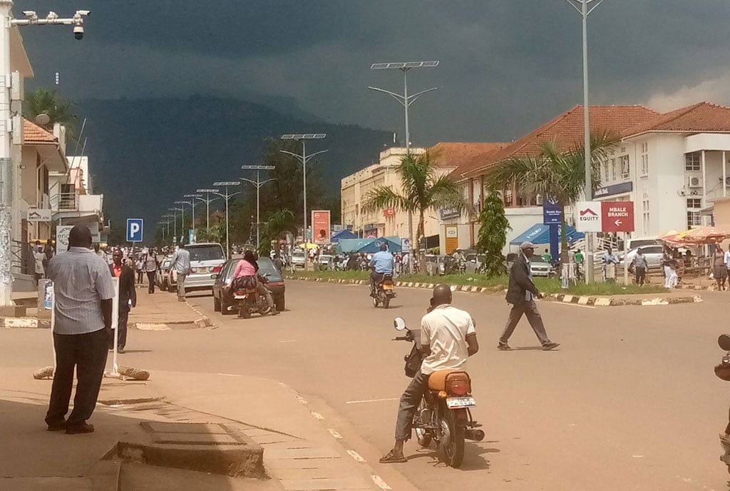
Motorists ride through Republic Street on Mbale City. A section of locals and leaders have blamed the current city challenges on poor physical planning. PHOTO/FRED WAMBEDE

What you need to know:
- The original greater Mbale plan, which was adopted in 1969, envisioned Mbale to be an administrative centre with gazetted places.
The alleged mess up of the physical plan of Mbale City remains a matter of debate with a section of locals and leaders blaming it for the current city’s predicaments.
Mr Abbas Wataka, who contested for city mayorship on a National Unity Platform (NUP) party ticket in the 2021 General Election, says flooding and congestion are a result of poor physical planning by the city council fuelled by corruption and incompetence.
“Whenever it rains, the city floods and apart from that, we also are experiencing congestion but all this is because of corruption among the leaders that caused the physical plan to collapse for selfish gains,” he said, adding that the only solution is to stop corruption and elect pro developmental leaders.


Mr Wataka is currently leading the Civil Plan for National Resistance Movement (NRM), a governance pressure group.
In August last year, devastating floods hit the city, leaving 29 people dead and several injured after River Nabuyonga burst its banks following a downpour.
Mr Wataka said the floods occurred because the places that used to absorb excess water have been turned into settlements under the watch of political leaders and technocrats.
“Places near River Nabuyonga, which were reserved to absorb water, now have buildings and this disorganisation, among other things, causes floods,” he said.
Monitor has learnt that places such as Senior Quarters, which were planned as residential for the upper class, now risk becoming a slum area because land owners have started dividing their plots into several pieces to sell to prospective buyers for settlement.
Similar issues are reported in Maluku, Namakwekwe, Indian Quarters and Half London, where people are fond of building houses on road reserves and blocking lanes.
“This is not the city I knew, this is something else. Places that were reserved as green cover and open spaces now house people’s buildings,” Mr John Mudebo, an elder and a resident of Nkoma, said.
Mr Mudebo said the original greater Mbale plan, which was adopted in 1969 by the then UPC government envisioned Mbale to be an administrative centre with gazetted places for different structures such as airstrips, but implementers have disregarded the plan.
“The physical plan had structures such as airports, children’s parks, and rugby fields like the one in Busamaga, but we were told recently that part of that land was parcelled out and sold to developers. Our forefathers who had a great plan for Mbale must be disappointed,” he said.
Mbale, which was upgraded to city status in 2021, is home to Bugisu Sub-region with a population of about 1 million people.
ALSO READ: Mbale just a city on paper, residents say
It has two city divisions, Northern and Industrial. Northern Division comprises the Northern Division, Nakaloke Town Council and sub-counties of Bukonde, Nakaloke, Namasaba, Lwaso, and Namanyonyi.
The Industrial Division is made up of Industrial Division, Bugema-Nauyo, Wanale, Bukasakya and Nambale (Bungokho-Mutoto) areas.
Independence
Mr Joseph Wanzusi, a veteran journalist, said Mbale was regarded as the third largest urban centre after Kampala, and Jinja and after Independence, it became a commercial centre attracting Indian traders.
“The Asian population had by 1959 increased to about 34 percent of the entire population of Mbale and Africans were few. The involvement of Africans in trade started after World War II and after Bugisu Cooperative Union (BCU) and Masaba Cooperative Union (MCU) were established,” he said.
He said in 1972, the situation changed in the town after Asians were chased away by Idi Amin and their properties were allocated to Africans who did not have any business knowledge.
“Africans used to be house helpers of Asians in this town and when the Asians were being told to go, the house helpers had to take over their business yet they had no knowledge,” he said.
Mr Wanzusi said Mbale Town was planned for a population of about 25,000 people in 1972, but when it became a municipality, its boundaries were expanded though its physical plan remained intact and there were no distortions.
Mr James Kutosi, the public relations officer of Mbale City, said new developments that have cropped up, including population growth, have had a negative effect on the physical planning of the city.
“As we speak Mbale City has a population of about 1.2 million people, this means the Mbale of then cannot be the Mbale of today. Today there is a lot of pressure on land and other utilities, and that is why the number of open places is no more,” he said.
Between 1960 and 1970, Mbale attracted many industries both large and small scale, including the African text mile (ATM).
“ATM was an industry which used to make materials such as bed sheets and it was employing more than 200 workers,’’ Mr Wanzusi said.
Mr Moses Wandulu, a resident of Nakaloke in Northern City Division, said the construction of buildings is being done contrary to the urban authority rules and regulations.
Mr Wandulu said the first mayor of Mbale was the parish priest of St Austin and he was called Fr Joseph Van Ven under whose leadership Mbale was named the cleanest town.
“He was not a Mugisu, but when we started electing our own sons, they started disorganising the town and grabbing whatever they came across. Corruption becomes the order of the day, washing away the gains,” he said.
Mr Latif Manana, a resident of Industrial Division , said the Kumi-Soroti road, which had been planned as two way carriage upto Kachumbala in Bukeda District, has become narrow because of growing traffic on the route.
“The people who own plots on the route have also encroached on the road reserves. In the middle of the city, there is a lot of traffic congestion because of disorganisation,” he said.
City rush hour
During afternoons and evening rush hour, the city is thrown into total confusion as vendors, buyers and pedestrians use the busy lanes, especially on Kumi and Bishop Wesikye roads.
Most streets in Mbale City are flooded with merchandise. The most affected streets are Naboa Road, Central Road, Cathedral Avenue, and Bishop Wasikye Road.
Mr Hassan Madoi, a businessman, said the city is experiencing high population growth coupled with inadequate waste management besides poor waste disposal, poor sanitation, pollution of water sources, and deforestation.
“The main challenges facing Mbale are haphazard developments on the existing land, worsened by overpopulation and greed by the technical staff,” Mr Madoi said.
Mr Hussein Kadimba, the speaker of the Northern City Division, said despite the challenges, Mbale is now growing fast because of the improved road network under the Uganda Support to Municipal Infrastructure Development programme funded by the World Bank.
“The population is now too high compared to back then and but we are doing our best to bring back the lost glory of our city,” he said.
Police statistics
Police records indicate that in a month, they register about 20 to 25 cases of land grabbing up from 10 to 15 in the previous years. They attribute this to the increase in prices and demand for land, especially in the suburbs and the neighbouring sub-counties.
Monitor understands that a 100 by 100 ft plot now goes for about Shs100m, up from Shs50m three years ago.
Mr Kutosi said since Mbale is a regional city, it is an intersection point for many areas and it’s also close to the national boards of kenya from Busia, Malaba, Lwahkaka to Bukwo, which makes it vulnerable to new developments.
“There are new developments, for example the establishment of industries such as Sino Industrial Park, which manufactures bulbs, stockings, carpets, and mattresses, among others,” he said.
The city mayor, Mr Cassimu Namugali, blamed the mess in the city on mistakes made by his predecessors.
“It is true there have been mistakes done by our former leaders, especially when it comes to the management of the open spaces, but we working to correct some of the mistakes,’’ he said.
He also said that they are planning to come up with a master plan for the city, but they lack enough funds.
“We need to review the physical plan to match the standards of the city from one of the municipalities,’’ he said, adding that the road network has increased from about 120kms to about 375kms.
About Mbale
Mbale became a township in 1906 and by 1951, the town had built modern offices on what is now called Republic Street.
After its Independence in 1962, the Mbale Municipal Council was the first town to be granted the official status of an urban authority. The Late President Apollo Milton Obote referred to it as the “Jewel of East Africa”.
Mbale rotary club then described it as the town with the best and most well-designed roads.