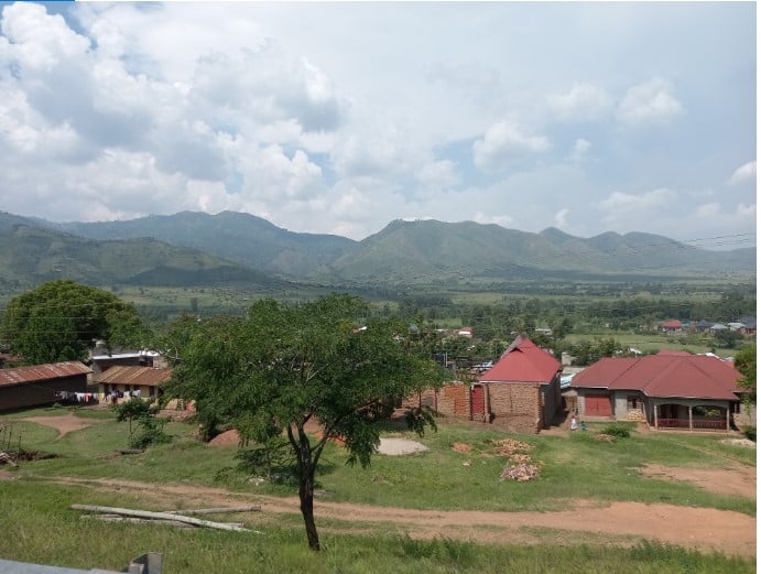
Rwenzori Mountain ranges seen from Kasese Town. The mountain ranges contribute a lot to Uganda’s tourism and food growing in the region. It is also a water source for River Nile. PHOTOS/ANDREW BAGALA
The journey from Kampala through Mubende to Fort Portal and Kasese before reaching the border town of Mpondwe spans 425km. Depending on the day’s traffic, it takes just under 10 hours to get to one of the busiest border crossings between Uganda and the Democratic Republic of the Congo (DRC).
During my journey, the private bus I boarded was held up in a traffic gridlock at Busega in the capital for more than two hours. Kampala Capital City Authority (KCCA) and National Environment Management Authority (Nema) officials were evicting hundreds of people from the Lubigi wetland. The wetland is a key catchment area and filter of water before it ends up in Lake Victoria. Wetland encroachers had turned part of this sensitive water catchment area into a market, tree nursery beds, and other economic activities that are detrimental to the ecosystem. The enforcement officers, using graders, pulled down illegal structures.
Once the traffic jam unlocked, the driver stepped on the pedal so as not to be caught up in the blows between the encroachers and enforcement officers. The Kampala-Mpondwe Road cuts through eight districts, linking the world to several tourism sites, natural forests and trade to western part of Uganda and beyond.
Our first stopover was Buloba township in Wakiso District, where we got something to eat at a roadside food market. The driver made it abundantly clear that the next stopover would be when we reached Mubende township, about 130kms away. So we all got what would help us recharge our batteries for the next stretch.
Soon after exiting Wakiso District, hills that were shielded by forests were covered by tree plantations. While most of it is public land, private people were allowed to cut down natural trees and replace them with plantations. Some private people given rights to plant plantations also changed the ownership of the land to freehold in their names. Big chunks of the land have since been fenced off.
Fenced-off plantations have left many locals without water and energy sources. Before the plantations, the locals used to fetch water and wood from the forests unrestricted. Owners of the plantations defend their actions, saying the local people deny them income by illegally cutting their trees. They also accuse the locals of setting uncontrolled fires that burn their coniferous trees, which are highly flammable.
The wood products from the plantations have supplied the city with wood and roofing materials at the time when hard wood has become so scarce. Tree plantations stretch miles and miles through the districts of Mityana and Mubende. Fewer banana and other types of food plantations are visible on the roadside throughout that stretch.
Bumpy ride
The journey is interrupted by potholes and largely snail-paced repairs on the road towards Mityana District. These interruptions go on at different sections from Mityana to Mubende and Kyegegwa districts. In fact, frequent users of the highway have severally complained about the state of the road that links Kampala City to key strategic places in the country. It connects to Queen Elizabeth National Park and Kibale Forest National Park that attract thousands of tourists.
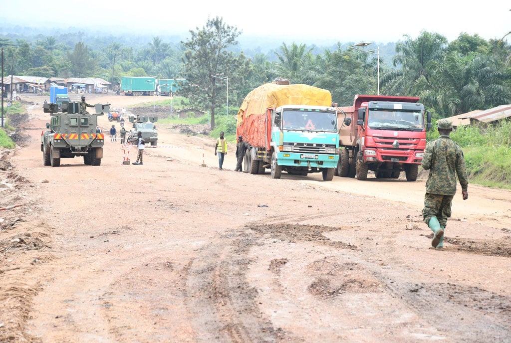
The road is also a major route for cargo transported to the DRC, which is the second biggest export destination of Ugandan products. The contractor partly worked on it and then parked most of the equipment. Drifting through those potholes at night is irritating.
The dust-ridden graded stretches compel vehicle occupants to close their windows, impeding them from having a good sight of the nice hills covered with pine trees.
Along the way, wreckage of vehicles that veered off in the pothole-ridden sections of the road give a clear indicator of the impact the bad sections have had on the motorists. Criminals, who waylay traders at night, have been taking advantage of these bad sections, most of which are in wetlands. When motorists reduce speed at pothole sections, armed criminals rush from their hiding and put the drivers at gunpoint. They empty the occupants’ pockets before fleeing.

The journey is interrupted by potholes and largely snail-paced repairs in Kasese Town.
Unlike on many highways in the country, few traders sell foodstuff and other merchandise to the motorists on the Kampala-Mityana-Mubende section. You have to travel all the way to Mubende Municipality to get a place where you can get a decent meal. The municipality has a food market in a clean place that operates 24 hours a day. Needless to say, its hygiene and affordable food items make it popular with travellers.
Changes
After Mubende Town, the land is sparsely populated and forested. Driving through beautiful thick forests, like Matiri Central Reserve Forest, in the districts of Kyegegwa and Kamwenge, is life-changing. The weather is cool and quiet. Signs of encroachment on many protected areas are there for all to see.
Even more troubling, the forests have become a sanctuary for the Allied Democratic Forces (ADF) rebels. At dusk, motorists are hesitant to travel through them for fear that they may be attacked by the rebels. Despite the threats, neighbours of Matiri Central Forest Reserve are busy with farming and mixed cropped plantations. Good weather in the area is favourable for coffee, bananas and tea growing. It is the best time to open a vehicle window to enjoy the cool fresh air.
The joy is only interrupted by human settlements a few kilometres to Kyenjojo Township. Kyenjojo is a growing town council where agricultural products are in plenty, but bananas stand out. In the evening, workers load bunches of them on the trucks heading to the capital.
Traditionally, Kyenjojo has gravitated toward tea, coffee, and maize in that order. Farmers in the township have in recent times picked interest in the growing of bananas because of the ready market and stable prices. Plummeting tea prices have forced many to abandon the crop.
Trouble in paradise?
Plantations along the way will only be interrupted by Kibale National Park, whose trees give a heavy cover of the road. Travelling through the forest is a memorable moment.
Its air is fresh. Birds sing and primates chatter and howl all day as branches of the tropical trees fan the environment.
Kibale National Park, a 795-square kilometre preserved area, is home to 13 species of primates and 325 bird species. Tourists all over the world travel to Uganda to trek the park and see the primates. Given its importance to the country, terrorist groups have attempted to disrupt the tourism sector by attacking the residents and creating panic.
Both the United States and the United Kingdom have issued advisories, warning their citizens from visiting the national parks in the western region. The scenery and wildlife of the park is so irresistible that many tourists continue flocking it. The government has increased the number of security personnel in the park.
Not far from Kibale National Park is Fort Portal City, the tourist city, which is considered to be the cleanest in Uganda. The weather, roads and cleanliness is breath-taking. Fort Portal’s lakes and hills are magnets for tourists.
Youth unemployment
As you travel westwards, the signs of prosperity fade. Townships like Rubona, Kibito, Kasunganyanja on Fort Portal-Mpondwe Road, are growing. But also so are the numbers of youth playing cards or just seated on the shop verandas and boda boda shelters during working hours. The population of youth in the region is growing rapidly before the available jobs and struggling tea sector. Many of the youth rush from the villages to the roadside in urban centres with the hope of trying their luck on getting money through odd jobs.
Farther westwards, farmlands and tropical forests become fewer. Hills and Rwenzori Mountain ranges with barely any trees become the main sceneries to watch. The cold weather is, at once, replaced by a hotter version.
From far after Rwimi Township, an imposing creamy coloured structure might fool you that it is part of the natural feature. It is a Hima cement factory. Its towering mega structure can be seen miles away. The factory employs hundreds of people, creating indirect employment and businesses for thousands of others. This is so much so that a town has grown around it after years of cement production. The cement production has come with environmental challenges and the creamy roofs of the houses keep the evidence. Particles released in the air during the production of the cement staddle more than 10km, affecting the health of the residents, water sources and farmlands. Balancing the benefits of the cement factory and environmental hazards has been a tough debate among government agencies and civil society.
Raining on one’s parade
It is one of the few factories that remain operational in Kasese District. The shock of environmental degradation is silenced by the Mubuku Irrigation Scheme that stretches miles and miles along the road. The scheme, a 5,000 hectares piece of land, was established 70 years ago to improve food production in the region. Beans, groundnuts and rice are now the major food crops grown in the scheme all year round given the constant supply of water from Mt Rwenzori ranges to River Sebwe.
Although the water from the mountains is the lifeline of the scheme, during the rainy season, it causes havoc to residents in Kasese Town. A bumpy section near the bridge crossing at River Nyamwamba is evidence of the trouble it causes. On a sunny day, River Nyamwamba looks harmless, but during the rainy season, it often bursts its banks, carrying huge stones downstream that hit people, sweep away houses, farmland and roads.
Over the years, hundreds of people have died due to River Nyamwamba’s rage. Sometimes when it rains, the road is cut off, forcing motorists and pedestrians to wait for hours, if not days until the floods recede.
On a normal day, the greyish stones along the river are nice to see and you will reach the centre of Kasese Town dazzled by their beauty. Kasese Town is equally a beautiful and busy urban area overlooking the mountain ranges. The government has resurfaced many of the roads in Kasese Town. Locals say the town used to be busier than it is now when copper was being mined at Kilembe, and when the railway line was active in the 1970s and 1980s. Both activities have since ceased and had a great impact on the town’s economy and life.
Closing shop
Experts left, followed by those who provided them with services. Education, health and the economy meant for the middle class literally went with them. Kilembe Mines Hospital was closed after heavy floods. Schools that used to produce the best students in the country are shadows of themselves.
The management of Hotel Margherita struggles, often unsuccessfully, to clear the bush off its compound and environs despite being strategically located near the Queen Elizabeth National Park and at the foothills of Mountains of the Moon.
Former army commander, Gen James Kazini (RIP), who hailed from the area, also constructed a multi-billion hotel, Kepp Resort at the foothills of the Mountains of the Moon to tap into the tourism sector. Unfortunately, the business struggled and in 2011, it was sold to a Kampala City businessman, who renamed it Springs International Hotel. Its troubles still continue.

The writer in front of Mpondwe Lhubiriha Market in Mpondwe Town in Kasese District. The market feeds both residents from the DR Congo and those in Uganda.
Interestingly, cottages and guest houses are doing well in the district. In Kasese Town, low budget guesthouses at Shs30,000 per room are busy and are attracting a good number of clients, especially travellers. Near tourist attractions, cottages are the thing and they are pricey, with each room going for as high as $500 (about Shs1.8m) a day.
Ugandan investors have invested in a lot of cottages, especially on the Queen Elizabeth National Park boundary on Kasese-Mpondwe Road. Queen Elizabeth National Park border has an electric fence that covers miles. The electric fence is a tool that brings harmony between the wild animals and the communities living near the park. Elephants and buffaloes are unable to leave their sanctuary and wander into people’s gardens. The electric currencies of the wire are a bit friendly in that they don’t electrocute the animal to death, but it shocks it and gives it a chance to learn and never attempt to touch it. Without a fence, the conflict between the residents and the animals would have been terrible.
Feeding DR Congo
On the right side of the Kasese-Mpondwe Road are plantations of maize, beans and cotton that cover square miles of land. Both are delicacies of buffaloes and elephants. It is those expansive fields that have made Kasese the leading cotton-growing district in the country. Much of the produce-filled trucks on Kasese-Mpondwe Road head to the Congolese border. The maize products feed the Congolese across the border and the rest is transported to Kampala City.
The sparsely populated area is sometimes invaded by armed groups, especially the Allied Democratic Forces rebels, who target trucks and their operators. In October last year, a truck carrying onions to DRC was waylaid by the rebels, who shot two people dead and abducted another. The place where the attack happened looks so peaceful during the day. And it is near a military detach. As we drove by, people were busy carrying out their work.
As you approach Bwera Township, urban lifestyle is visible. The township is a busy place and well-developed. There are signs of prosperity given the huge and nice buildings. In fact, you would encounter traffic gridlocks during rush hours. It is where trailer and truck drivers often rest before they embark on the journey to the DRC.
The town has also suffered several threats from ADF and other armed groups for years. And the presence of heavily armed soldiers patrolling its streets is a clear indication of the security challenges it is faced with.
A 6.5km stretch separates Bwera from Mpondwe Town. Bwera is well maintained and in contrast to Mpondwe, where you are welcomed by heaps of garbage along the roadside. The nature of the people who stay in Mpondwe also contributes to its problems. Most of them are visitors transiting to and from the DRC. Majority of them spend the night in their vehicles, so whatever they consume, waste is dumped on the roadside.
The huge number of trucks carrying cargo from Uganda heading to the DRC shows how important the neighbouring country is to our economy.