Prime
Ntoroko seeks Shs850m to combat river flooding
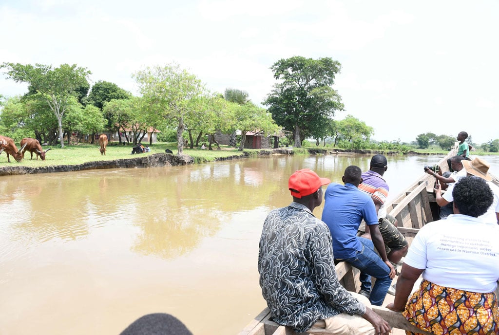
Ntoroko District leaders inspect collapsed banks of River Semliki in Bweramule Sub-couty in early August 2024. PHOTO/ALEX ASHABA
What you need to know:
- The floods destroyed the main access road connecting Bweramule and Rwebisengo sub-counties, washing away the Kyobe-Bweramule bridge, which was under construction.
River Semliki flooding has displaced residents with water extending up to 10 kilometres inland, which has also damaged roads.
Ntoroko District leaders have called on the government to provide Shs850 million to construct embankments at critical flooding spots on the Semliki River.
The Ntoroko District Chairman, Mr William Kasoro, said frequent floods have resulted in riverbank collapses, which have severely impacted people’s lives.


He noted that human activities on the Ugandan side have weakened the riverbank, while the riverbank on the DR Congo side remain intact due to the absence of such activities.
“The government needs to provide Shs850 million to construct additional embankments along the Semliki River,” Mr Kasoro said, adding: “We have demonstrated that these embankments are effective. With increased funding, we can manage these floods more effectively. This is the only viable solution.”
Mr Kasoro further emphasised that increased water volumes in the river do not flow into the DR Congo side, where protective measures are in place.
Instead, the entire volume of water is diverted towards the Ugandan side, leading to riverbank collapses, displacement of residents, and flooding extending up to 10 kilometres inland, which also damages roads.
The most affected areas include Kayaja III, Haibale, and Budiba in Bweramule Sub-county, where urgent restoration efforts are needed to prevent further erosion and loss of land.
Earlier this year, in collaboration with the Food and Agriculture Organisation (FAO), Ntoroko District used more than Shs300 million to construct embankments at some key flooding points in Bweramule Sub-county.
During recent floods, these embankments successfully prevented overflow in targeted areas, while flooding occurred in other areas lacking such structures.
Ntoroko District Engineer Richard Kakuru explained that the embankments are designed to extend 500-metres with a thickness of 1.5 metres above ground.
In areas where residents had dug canals, an additional depth of 2 metres was added. Vegetation was also planted along the riverbanks to provide further protection.
A report released in April by the Ntoroko District Environment Officer, Mr Herbert Kamuhanda, indicated that approximately 20 to 25 acres of land on the Ugandan side had been lost due to the collapsing banks of the Semliki River.
The most affected area was Rukora Village in Bweramule Sub-county, where land previously used for agriculture has been submerged by the river.
The report noted that the river had diverted towards the Ugandan side, altering the boundary between Uganda and the Democratic Republic of Congo. The main causes of the collapse were identified as human activities, including crop cultivation, livestock watering, and community footpaths along the riverbanks.
These activities have deprived the banks of vegetation, loosening the soil and leading to rapid collapse on the Ugandan side, in contrast to the DR Congo side, where human activities are minimal.
The Semliki River, which originates from Lake Edward and has its main catchment in the Rwenzori Mountains, forms the international boundary between Uganda and the DR Congo before draining into Lake Albert. On the Ugandan side, the riverbanks are collapsing, while on the DR Congo side, the vegetation remains thick, preventing such collapse.
Local leaders have expressed concern that the continuous collapse of riverbanks on Uganda’s side has displaced households that were previously situated more than 100 metres away from the river.
The report indicates that approximately 14 households have been affected, highlighting the urgent need for intervention to prevent further displacement and land loss.
Over the past three years, repeated flooding from the Semliki River has caused significant devastation on the Ugandan side, displacing hundreds of people and damaging properties in Bweramule, Butungama, and Rwebisengo sub-counties.
Last Friday, more than 9,000 people in Bweramule sub-county were displaced, and around 50,000 cattle remain stranded in floodwaters after the Semliki River burst its banks again.
Floodwaters have also extended to Butungama Sub-county, leading to the temporary closure of Masaka Primary School, which serves more than 400 pupils.
The school headteacher, Mr Vincent Asiimwe, indicated that the school might not reopen soon as water has already entered classrooms and staff houses, and access to the school now requires a canoe.
The floods have destroyed the main access road connecting Bweramule and Rwebisengo sub-counties, washing away the Kyobe-Bweramule bridge, which was under construction.
Additionally, government infrastructures, including army detachments and migration offices along the River Semliki, are no longer accessible by road due to the flooding.
The flooding has also cut off Bweramule Primary School and the primary cattle water source in Kyapa.