Leaders decry Mpanga, Semuliki degradation

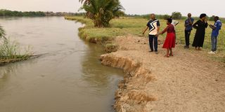
The Ntoroko District chairman, Mr William Kasoro (left), with other leaders inspecting banks of River Semuliki in Kyagabukama Village on June 22. PHOTO/ALEX ASHABA
What you need to know:
River Mpanga originates in Rwenzori Mountain and goes through four districts (Kabarole Kamwenge, Kitagwenda and Ibanda) and Fort Portal City while the Semuliki river traverses Ntoroko District at the Uganda and DR Congo border
Leaders are concerned about the continued degradation of River Mpanga and Semuliki catchment areas in Tooro Sub-region.
The leaders have now called for a special fund to conserve and restore the catchment.
Degradation of the river and catchment areas had led to a reduction in the water volumes and quality.
The Kamwenge District chairman, Mr Joseph Karungi, said most wetlands in the district have been encroached on because they are not gazette.
“We need to demarcate boundaries of River Mpanga and other wetlands in the region and thereafter start mobilising resources for conservation,” he said.
The chairperson for Kabarole District, Mr Richard Rwabuhinga, warned that lakes and streams might dry up in the future of the riverbanks and their catchment areas are not protected and restored.
“The districts that are trying to protect catchment areas have plans but they don’t have funds for implementation and now we are appealing to the government to set aside resources for implementation of developed plans, the government has left the work to the private sector,” he said.
River Mpanga originates in Rwenzori Mountain and goes through four districts (Kabarole Kamwenge, Kitagwenda and Ibanda) and Fort Portal City while the Semuliki river traverses Ntoroko District at the Uganda and DR Congo border.
River Mpanga is a major source of water for mini irrigation of water for production in Rwegaju Sub-county in Kabarole, National Water and Sewerage Corporation (NWSC) in Fort Portal and Mpanga Hydro-Power in Kamwenge.
The Senior Environmental Officer of Fort Portal City, Ms Gladesi Natugonza, said the city lacks an inventory for all wetlands, derailing enforcement and conservation efforts.
Ms Stella Kugonza from Kyabikokoni Village said: “During the rainy season you cannot fetch water from River Mpanga and use it for cooking or washing clothes because it is always dirty. The water is always mixed with sand and other faecal matter because there are many human activities along the river banks in Karangura Sub-county where the river originates,” she said.
Ms Kugonza said most households resort to buying water from a public tap at Shs 200 for a 20-litre jerrican during the rainy season.
The Fort Portal North Division Mayor, Mr Joseph Mashubuku, said previously they took to court about 45 people facing charges of destroying the environment; but said they lost the case because some encroachers had approved plans.
The Ntoroko District chairman, Mr William Kasoro said there is a need to stop all human activities along the river banks.
“The most dangerous human activity that is destroying our river banks is cattle grazing. Cows graze on river banks and drink water directly from the rivers,’’ he said.
Mr Kasoro proposed that there is a need to demarcate the 100 metre buffer zone for the rivers to stop animals from destroying their banks.
Restoration efforts
The country Director of Join for Water, Mr Isaiah Ndungo, said they have secured Shs1.5 billion from the Belgian government to restore and conserve Mpanga and Semuliki river catchment areas
He said Natural Resource Defense initiative (NRDI) and Joint Effort Save Environment (JESE), both non-governmental organisations, have been contracted to implement a 5-year restoration and conservation plan. The plan runs up to 2026.
“We recommend structural constructions like gabions on hotspots of the river banks,” he said.


